Discover rewarding casino experiences. 
Click on the Flag for More Information |
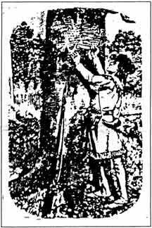
The document quoted above in the possession of the Chicago Historical Society is the first deed of land in Illinois to be executed (de la Forest to Acau) friend of the above named Tonty, who was a partner of the explorer LaSalle. The bill of sale covered one quarter of the present boundaries of Illinois for the consideration of 6,000 liveres (then French worth a pound of silver) or $1,200 in beaver pelts. This may seem like quite a bargain but the French at that time were holding such a surfeit of land that they considered Illinois holdings to be of very little worth. Sales were made at bargain basement prices. In 1693 no one could have foreseen the future wealth of Illinois or the desire of it. It wasn't until a hundred years had passed that anyone much sat up and took notice. Before that the Eastern states had a system of land measurement which was known as 'Metes and Bounds.' The beginning or end of any distance then was a natural "monument" such as a blazed trail, a white mark done by cutting away the bark on a tree (see "D. Boone!"). Or perhaps a pile of stones planted as a point of reference by a surveyor. Those measures (metes) and limits (bounds) when set out in nomenclature make up the description of a particular piece of land. Such description can be involved and tedious. They were difficult to follow as if to form a labyrinthine puzzle. They may have suggested the inspiration for a more efficient system, one reference states. Thanks to Thomas Jefferson, the date May 20, 1785 was a red-letter day, one for the state of Illinois (then still "Virginia"). After that date there were no "tomahawk claims" as they were called, when a settler could stake out his own domain zigzagging irregularly as he wished over all sorts of acreage, hoping later for it to qualify as a proper homestead. Many claimants were sorely disappointed to learn that their haphazard metes and bounds were not theirs after all, such as Abraham Lincoln's father, Thomas, learned in Kentucky when he lost property due to having had no accurate point of reference. That year, 1785, Congress adopted the surveying of public lands in the Northwest Territory (of which we were a part). It became known as the "rectangular system" which was devised by a British officer stationed at Ft. Chartres, an elaborate outpost in the wilderness of Illinois country by the Mississippi River near present day Kaskaskia (last week, Thomas Hutchin). Hutchins had served in the French and Indian wars as a British assistant engineer but during the Revolutionary War his sympathies were with the "colonists" so he resigned from the English military. In 1779 while in London he was accused of treasonable correspondence with Benjamin Franklin and imprisoned in the Tower of London but escaped to return to America. After the Revolution he had charge of the survey of the Northwest and personally ran the first meridian upon which the system depended. Thirty states afterward adopted the orderly rectangular system which resulted in a minimum of dispute about boundaries due to the excellent and efficient work of armies of surveyors who endured untold hardships to "run a straight line" through swamp, bog, palisades and hypnotic, dizzying endless prairies in summer and frigid conditions in winter. Congress modified the 1785 law in 1796 but which is still in force over two hundred years later ... Under it, all public lands are divided into townships, six miles square. Lines are drawn on true meridians and true parallels of latitudes. First there is established a principle meridian and at right angles thereto, a baseline conforming to latitude is established as a guide and also a guide meridian twenty-four miles east or west running due north or south and intersecting the standard parallel at right angles. The rectangle thus formed is divided into sixteen townships wherein the tiers of townships are numbered north and south of the baseline and rows of townships east and west of principle meridian. The First Principle Meridian coincides with the boundary between Ohio and Indiana, the Second passes through Indiana a little west of the middle and the Third which mainly controls the surveys of our area, skirts the eastern edge of Stillman Valley in Ogle County. The Fourth which is the initial line for numbering sections on this side passes just east of Galena. Most of you are aware of Meridian Road that extends into Winnebago County northward but may be unenlightened as to the fact that it is a remnant of the marking/making of Illinois from earliest times. The Base Line of the Third Principle Meridian has its east end on the Wabash River, a few miles north of Mt. Carmel and its west end on the Mississippi, a little south of Bellville; that for the Fourth Principle Meridian has its east end on the boundary line between Illinois and Indiana at a point five or six miles south of Danville, while its west portion passes through Beardstown and if extended would intersect the Mississippi five or six miles north of Quincy! Each township so surveyed is known as a Government or Congressional township and is divided into thirty-six sections, each one mile square, containing 640 acres. The sections are numbered from one to thirty-six beginning at the northeast corner going to the left to six then dropping to the next section underneath and counting to the right to twelve and so on. The rectangle that it makes is slightly longer at the bottom because of the curvature of the earth. A correction line is necessary at the base line for the next rectangle, etc. It also counts for fractional sections, which when necessary to be made, are always the eleven sections on the north and west of the township, the other twenty-five being "full." Up until just prior to statehood unsurveyed land was of little interest to most. But in 1814 the government was ready to offer public land for sale although surveying had begun four years earlier. Of course, the Illinois country had begun to be settled more than a hundred years before down in the American Bottoms when the French pioneered in the remote wilderness. Those families by the nineteenth century were a couple generations into residency with, plus, later emigrants who'd survived the Revolutionary War. However, they had no legal title to their homesteads. Congress though granted them their rights in a somewhat questionable manner that merely had heads of family obtain written testimony from friends or neighbors saying that they had lived at a particular place prior to statehood. In our files (!) is a record wherein those applications are shown, stating that they had "cut wood" or "planted a garden" at a site for so many years before to prove their "improvements," residing at a certain place the necessary number of years. Congress also granted four hundred acres of land to heads of family who had lived in Illinois prior to 1783 or after for a certain number of years. Two hundred forty-four "head rights" claims were filed and okayed in the casual manner accepted. Many of those names on this record became Carroll County pioneers. After the War of 1812, the "rush" to Illinois began which jeopardized the claims made or held by previous settlers who were fearful of losing their valuable improvements some of which were begun thirty years before. When land offices were opened in Shawneetown and Edwardsville in 1812 and 1816 squatters hurried in with proof or crying for the safeguard of their property. A pre-emption law (3rd volleyball game) was endorsed by Illinois' first governor, Shadrach Bond, and such were periodically modified to the benefit of the Illinois settler who built the state. Almost all early Illinois land was bought on credit. An amendment in 1804 had authorized the sale of quarter sections, 160 acres, and that minimum was again halved to eighty acres in 1817, a more manageable size for the ordinary claimant who could afford little more or was able only to work that much land with the primitive implements of the day. A five percent down payment held the land forty-five days after which twenty percent was due. The balance was payable in three equal annual installments without interest. Land reverted to the government after five years delinquency. At first, the price per acre was set at two dollars but was reduced to one dollar twenty-five cents per in 1820 at which rate it remained until the last government land in Illinois was sold. The Rock River Register reported in 1842 that between June that year and November a "land office" business, indeed was done with the 224,000 acres being purchased in this locale. By 1850 land values had risen to five dollars in private transactions (without improvements) to fifteen or twenty dollars with more valuable timberland going for fifty dollars each. When lumber from the pineries became available, timber lots dropped in cost in sales, or stayed relatively the same. By the turn-of-the century they sold for fifty to sixty dollars an acre while farmland went for sixty-five to seventy-five, the latter increasing in price. The land sales, feverishly in vogue the first thirty years of so after statehood, eventually cooled off but it was much the talk of the nation as Illinois became an objective of settlement. Our forefathers planned well and platted well in eliminating the "tomahawk claim" of old, insisting on the "rectangular system" but because land sales and their regulation was a main topic of conversation of squatters, and later the actual ownership of a section or so, the nomenclature of land transactions were very often applied to other matters. If a young man paid attention to a young lady, for instance, he was said to be "making a claim." If it was understood that they were engaged he was said to have a "pre-emption" and if another cut him out, the successful party was said to have "umped his claim." So goes the course of history, real events prompting words and phrases which went into everyday conversation. Two consecutive "reruns?" After last week's, a couple people asked about this one, several years older because of its further details which they had "lost" in their "files." We decided to look it up ourselves. September 10, 1997 was longer ago than remembered, but it does reaffirm how the French were among the first of our earliest settlers, next week, and gives background on our orderly plat system. |