Discover rewarding casino experiences. 
Click on the Flag for More Information |
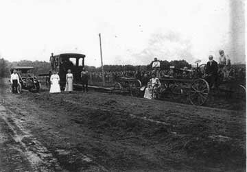
"Short quick and sharp was their order of business," according to the writer of the 1878 Carroll history. It was the character of the first chairman, Luther Bowen, "The guiding and controlling spirit of the board." The first order of business was to appoint three stalwarts to "review a road from Stoney Creek to the county line in the direction of Buffalo Grove, touching on Elkhorn Grove." Following this were two other petitions a "road from Savanna to Knox's Mill (Milledgeville) on the Elkhorn AND a road diverging from the first named at or near Johnson's Creek to the county line in a direction to Harrisburg on Rock River (Sterling)." Another petition located a road "from Savanna via Bowen's Ferry (Plum River) south to Fulton City with a divergent two miles south of the beginning to intersect a road leading from Savanna Mills to Prophetstown." As you see, roads were the first item to be considered in the business of building a county. One place to another had to be distinct and passable. And in several directions. The roads and bridges were covered by many directives ... "highway commissioners, besides vacating, regulating and repairing roads and bridges, should at all forks or crossings place at most important points, post guide boards with plain inscriptions, giving directions and distances to most notable places. Also, they must prevent thistles, burdock cockle burr, mustard, yellow dock, Indian mallow and jimson weed from seeding. Anyone running a horse over the roads should be fined $10 or serve sixty days in jail. The commissioners must also have a watering trough at such points as advisable to serve the public's livestock. Before the first day of May each year they shall make out and deliver a list to their treasurer of all able-bodied men in their town except paupers, lunatics, idiots and such others as are exempt by law ... To assess each man the sum of two dollars as a poll tax for highway purposes. Public roads should not be less than fifty feet wide nor more than sixty. Roads less than two miles long could be, if petitioned, forty feet wide. Anyone with a private road could work out their road tax thereon. Anyone could pay someone to work for their four days also! Early roads had been trails which took the "easy" way over hill and dale. Later in the nineteenth century roads were surveyed following township lines to help make ownership of plots more easy to sort out. Surveyors were among the first trades to be put to work measuring the state into grid-like acreages. Their work was so important that they were paid $6 a day, a tidy sum back then. As time passed the automobile appeared and better, passable roads had to be addressed as a project for township, county, state and federal governments. Roads were not only fundamental but necessity as land travel improved. The flivver stuck in the deep mud of a dirt road was a common sight. The neighborhood team of horses pulling the auto out of the mud was a well-known joke. By the 1920s paving of roads had begun. Brick for awhile was thought to be the answer to "hard roads." You could take up a few bricks and replace them if some accident occurred. Purington was a familiar name for the heavy, dark red paving brick. Many quaint streets of them are found here and there, still in good condition. But a gent who'd worked on highways back in the 1930s said a governor had a powerful friend in the cement business who'd give a "good price" if concrete, not brick, was used so Illinois highways were poured, not laid in brick!!!! (See PDQ Me - 3/27/85.) Whatever the material, hard-surfaced roads were the answer for a small town's future business-wise ... Highways of concrete were how automobiles, tourists, the local buyer, the stranger could get from one place to another with no getting stuck in the mud and all the other troubles which might arise. Hard roads meant progress just as once railroads were the dream of every community. A railroad through your town brought in trade and traffic, sent out market goods; settlers. In and out communities vied with one another to have a railroad just as they would in the twentieth century for hard-surfaced roads. Back in 1885 both Coleta and Milledgeville competed for a railroad. That rivalry would be repeated in the 1920s for a state highway of which the following story will make you aware. Those highways, hard-surfaced, would encourage trade. They'd boost sales, interest, people in new ideas, shorten travel times, change society all around. Routes would go directly through the town's commercial district so stores would be on immediate view. Today, of course, many routes by-pass the heart of a community, curving around the outer edges which certainly has changed the traffic, meaning sales throughout many towns. An example of this can be seen at Milledgeville where once Rt. 40 was routed through the commercial district, Main Street, which may come as a surprise to many of us. Rt. 40 which alternated now and then as Rt. 88, too, presently curves along the east and north sides of the town. At Mt. Carroll also Rts. 64/52 sweeps separately on its south boundary where in the natural course of things, businesses have developed and "Bobtown" has been revived. In the period of time that these events have taken place, many incidents had preceded them. The following tale is from the 1968 Carroll County history is told by the late Vernon Todd, Milledgeville, a wonderful storyteller and whose ancestry went back to the earliest settlement of the county. You'll see that all was not neatly laid out on paper to be accomplished without other perspectives some hard bargaining, knowing the right people (with political pull) and persisting towards the main objective ... "In the late 1890s gravel and paved roads were being built. Wysox Township (Milledgeville) voted a $37,000 bond issue to surface main roads leading into town and also heading south towards Sterling. William Wolber, Township Road Commissioner, who owned what was known as the Merlak farm south of Elkhorn Creek, improved a half-mile of road by his place. This road drew Sterling traffic to the Whiteside-Carroll County line and Milledgeville. The route was later marked the 'Indian Head Trail' and was first considered for the proposed new state cement highway #40. A gravel road had been built due north out of Sterling, later veering northwest, and since the road south from Coleta was unimproved dirt, agitation led by Loren Birdsall, chairman of the Whiteside County Farm Bureau Road Committee, and others began to bring Rt. 40 west from Sterling through Emerson and north past the Birdsall farm to Coleta and thence north and east to Milledgeville. "Governor Len Small in his first term in Springfield had stirred up opposition over his personal use of interest money on public funds during his term as state treasurer. Milledgeville Republicans were inclined to support Charles Deneen for next governor. "Attorney Mitchell of Sterling and the Birdsall committee had induced Governor Small to come to Coleta for a good roads speech. Reportedly he'd agreed to bring the new state highway within a mile of Coleta. "The first survey by the state was north out of Sterling to near the Carroll County line. This survey was stopped and re-directed to the west from what was known as the Pfundstein Corners to within one mile east of Coleta, thence north to Milledgeville. "As chairman of the Carroll County Farm Bureau Road Committee, I found a book in my father's library containing the enactments of the last Illinois legislature (1919) which included the $60,000,000 bond issue for locating and constructing state highways. The bill stated that Rt. 40 was to leave Sterling on the north, take a northwesterly direction to Milledgeville thence to Chadwick and Mt. Carroll. "With this description I went to Jordan Township (Whiteside) and contacted William Hacker, a former Milledgeville businessman, and John Hay, township supervisor. We arranged a meeting in the Gould schoolhouse. We learned that a committee was actively trying to get the route west of Sterling through Emerson, then north through Coleta. Our group was enthusiastic and agreed to support an effort to keep the route where it had been directed. I furnished the car and the committee, consisting of misters Hay, Hacker, James Lee and C.A. Spanogle, representing the Milledgeville Commercial Club, contacted state highway headquarters in Dixon; also State Representative John P. Devine, a Democrat, who later was elected Speaker of the House. "Mr. Devine knew of the dissension over the route but said he was not the man to see. We should contact our former State's Attorney and Circuit Judge, Franklin Stransky of Savanna. Judge Stransky was a close friend of Gov. Small and later became Republican State Chairman. We returned to Milledgeville, partly discouraged but after some discussion, Hacker and Lee accompanied me to Savanna. Luckily, we found Judge Stransky in his office. I had served four days on a grand jury under him so I did most of the talking. The judge said he represented Gov. Small in his interest troubles so we should not expect him to use this connection with the governor. However, he agreed to make an effort for us for a down payment of $600 and $2,500 if we got the road. The route was to enter Milledgeville at the Old Town Pump, as it is today. "After several meetings and a lot of bickering, the money was raised in Milledgeville and Jordan Township. Had this effort not been made, the route would have been one mile west of Milledgeville. Charles Kingery, a Chadwick banker, also a road committee member, caused the road to turn northwest of Milledgeville to Chisholm Corner (Sec. 5, Wysox), then west to Chadwick. Otherwise it would have followed the railroad." This first-hand story from the past makes us pause for reflection!!! The Old Town Pump mentioned in Mr. Todd's tale will be addressed next week.
|


